Spatial planning and One Map Policy in Indonesia
Spatial planning has a strategic position in Indonesia: it is a key instrument for establishing and sustaining government long- and medium-term plans (RPJP and RPJM) for national and regional development, promoting rational spatial organisation of land uses and reconciling competing policy goals. It aims to balance demands for development with the need to protect the environment and to achieve social and economic objectives.
Why is the One Map Policy (OMP) important? Reliable, accurate and up-to-date spatial information is essential for spatial planning. The development of such authoritative geo-spatial information currently faces issues such as map discrepancies due to the absence of standards for data classification, geo-database format and a range of geo-spatial reference systems. These problems make it difficult for policy makers to integrate maps generated from the related ministries and agencies. For this reason, the OMP is urgently required to avoid map conflicts and ensure all thematic maps comply with the same standards.
In February 2016, President Joko Widodo issued Presidential Decree No 9 Year 2016 on the OMP to speed up the implementation and production of a single, integrated, nationwide database of various political and economic information by 2019. This OMP will be implemented at the national and local levels. It is expected that land disputes – rampant for decades as a consequence of unreliable and inconsistent maps and data – can be reduced. From an economic perspective, the policy is also expected to stimulate and accelerate investment growth in Indonesia.
Riau’s pending spatial planning status impacts investment opportunities.
Until now, Riau Province has not regulated its Regional Spatial Plans (RTRW) and this situation has seriously affected the investment environment. Investors from national and local levels are discouraged by the absence of local regulation (Perda) of RTRW and are reluctant to invest. The stagnation leads to low rates of economic growth.
“The extension of previous permits and the issuance of new investment permits have a number of significant challenges now, including Building Permits (IMB). This permit stagnation is not only occurring at the provincial and district levels, but also nationally where the central government is also unable to issue investment permits in all districts of Riau.”
Secretary of Bappeda Riau Province, Supriyadi Riau Governor, Arsyadjuliandi Rachman, in his briefing to Land Equity International (LEI) on 6 April 2017 stated that one of the priorities of the provincial and district government is to ensure that the spatial planning process will only use the same basic map. For that reason, the implementation of OMP is a must and cannot be postponed in Riau and all districts. He also confirmed that there is a significant need for capacity building support to improve the capacity of human resources to manage and implement the OMP.
Through the support of Participatory Mapping and Planning Sub-Activity Project No. 7 (PMaP7), managed by LEI and funded by Millennium Challenge Account-Indonesia (MCA-I), OMP implementation in Riau Province (five districts) can be accelerated. The PMaP7 project will support building local government capacity in spatial planning at the province level and in the districts of Pelalawan, Kampar, Kuantan Singingi, Rokan Hulu and Rokan Hilir.
One Data One Map (SDSP): Learning from West Nusa Tenggara
Although PMaP7 only recently commenced in Riau on 13 April 2017, LEI has successful previous experiences in supporting the West Nusa Tenggara (NTB) Government to implement its OMP, called NTB One Data One Map (NTB SDSP). Through this experience, we learnt that the problems facing the Riau Government have also been experienced by the NTB Provincial Government.
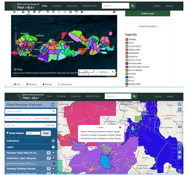
Presently, the NTB SDSP is fully functional with one geo-portal that facilitates the integration of thematic geo-spatial information from various agencies and that can be accessed by the general public, including local/national investors. A geo-spatial working group was established by Governor Decree (SK Gubernur) and coordinated agencies to develop the standards for thematic mapping and geo-spatial data formats for geographic information system application. With the funding allocation from local government, the working group continues to increase its capacity periodically.
The NTB SDSP is timely for encouraging investment. One example is the national tourism program that is now receiving investment in NTB through the Special Economic Zone (KEK) Mandalika in Central Lombok.
A number of examples of maps from NTB showing boundaries, weather and climate, average daily relative humidity, drainage network and patterns, etc. can be accessed through the following link: https://tinyurl.com/m2mv3on
The map examples above are sourced from PMaPWebGIS.com – a PMaP/MCA-I initiative within the wider Green Prosperity Program – “…aimed at representing the spatial information of the local area that combines modern cartographic technology with participatory methods”.