Celebrating Success through Innovation and Adaptation

LEI recently submitted the fourth progress report of the Papua Spatial Planning program or PSP as it is referred to, operating in Indonesia. Reporting on the past 6 months of project activities during 2021, the report reveals positive progress in the second year of the project with achievements against all of the key project indicators […]
A Learning from Papua – Capacity Building in The Time of Pandemic, written by Imelda Sihombing (LEI Associate)

The poor quality and availability of spatial data has always been one of the biggest challenges in spatial planning in Indonesia, and most importantly in Papua. Further constraining spatial planning and sustainable development challenges, though, is the severely limited technical capacity of local government staff. Recognising this, Papua Spatial Planning – a bilateral programme between […]
Adapting projects to COVID-19, written by Kate Fairlie and the PSP team
There have been many articles about the impacts of COVID-19 in the international development space – perhaps best evidenced in our sector by the 100+ articles on land and COVID-19 on the LandPortal blog. Development partners and practitioners alike have needed an unprecedented level of adaptiveness and flexibility to continue activities alongside this global challenge. […]
Recognising commitment and resilience whilst working remotely

We are very proud of our project teams around the world who have shown great commitment and resilience throughout these trying times.
Green and Inclusive Spatial Planning for Due Diligence
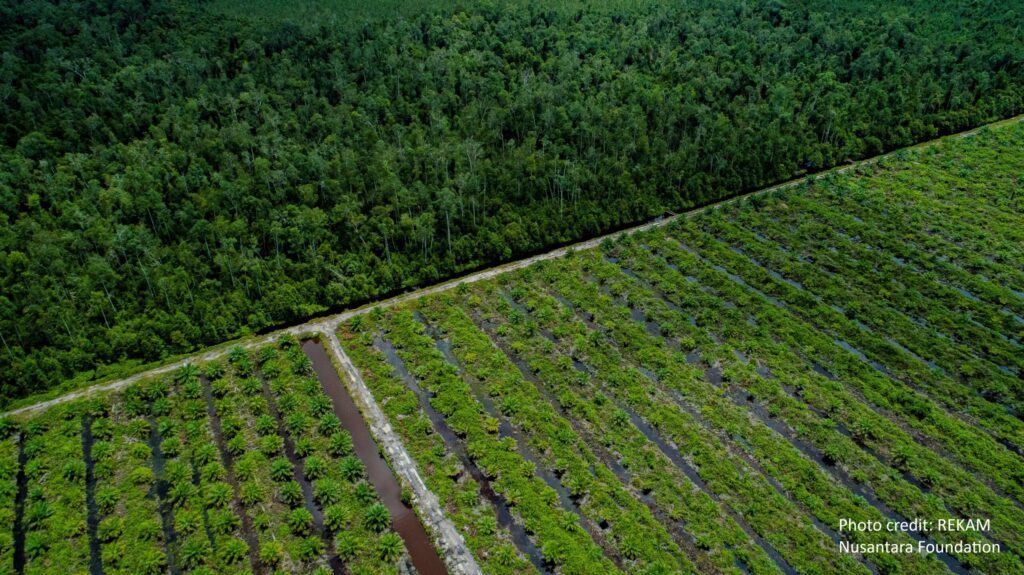
International deforestation statistics are compelling. Annual tree cover loss is regularly reported at the size of entire countries and is rapidly increasing. We know that addressing deforestation is essential to climate mitigation – yet forests receive just 3% of available climate mitigation finance. We advocated for more emphasis on green and inclusive spatial planning that is operating at National and Local governments that can work in collaboration with foreign and domestic investors.
Consultations Commence for the Papua Spatial Planning Project

Land Equity International and Daemeter Consulting are pleased to commence working with the United Kingdom’s Foreign, Commonwealth and Development Office (FCDO) via the UK Climate Change Unit in Indonesia (UKCCU) and the Government of Indonesia to deliver the program Reducing Deforestation through Improved Spatial Planning in Papua Provinces, Indonesia (Papua Spatial Planning – PSP). The […]
Participatory Land Use Planning: lessons 1 year on
Technical standards are essential for governments and professional bodies to regulate. But sometimes unworkable technical standards arise from false interpretations of government guidelines. Our lesson is to prioritise usability – particularly in the case of novice users – and to keep the project objective front of mind.
Achieving local government commitment to coordinated and improved spatial and land-use planning
MCA-Indonesia’s third project – Participatory Mapping and Planning Sub-Activity No. 3 (PMaP3) – focuses on eleven districts across four provinces.
Infographic video used to deliver key PMaP3 messages to local government and public audiences
Over the past 12 months, Participatory Mapping and Planning Sub-Activity No. 3 (PMaP3) has been delivering three tasks across 11 districts in Indonesia. The following infographic video was used as part of the stakeholder management strategy to provide a comprehensive and uncomplicated overview of PMaP3 to target audiences. It shows how the program was developed to address the problem of land use and space – a result of long-term poor planning and overlaps in spatial information management.
LEI wins World Bank-funded One Map TA contract in Indonesia
LEI has secured the Technical Assistance and Capacity Development for the Program Preparation to Operationalize and Accelerate the One Map Policy (One Map TA project). This 12-month TA project commenced in February 2017. It aims to support One Map Policy (OMP) implementation and strengthen the National Spatial Data Infrastructure (NSDI) through the early completion of OMP coverage across all of Indonesia.