Project Narrative
In late 2008, Indonesia was selected by the Millennium Challenge Corporation (MCC) Board of Directors as a country eligible for a compact. The Government of Indonesia (GoI; through the National Development Planning/National Development Planning Agency (BAPPENAS)), was responsible for coordinating the development and implementation of the Compact (MCA), which covered three key programs, one of which was the Green Prosperity (GP) Project. The Compact implemented gender activities, environmental assessments and social assessments to support program implementation.Projects such as these responded to constraints to economic growth and were priorities in the GoI’s national development strategy. The GoI made a commitment to reduce greenhouse gas emissions by 26 percent by 2020, while maintaining a target of seven percent annual economic growth.
The GP Project consisted of four procurement activities: (1) Participatory Land Use Planning Activity (PLUP); (2) Technical Assistance and Oversight Activity; (3) GP Facility Activity, and (4) Green Knowledge Activity. PMaP3 was the third project in a series of eight PLUP sub-activity projects. It covered three main tasks:
- Task 2: Acquisition of geo-spatial data and preparation of geographic information system (GIS) databases on land use/land cover
- Task 3: Compilation and geo-referencing of existing and pending licences and permits for land and natural resource use, and
- Task 4: Enhancing district spatial plans through capacity building in spatial planning, enforcement and management of land use information in spatially-enabled databases.
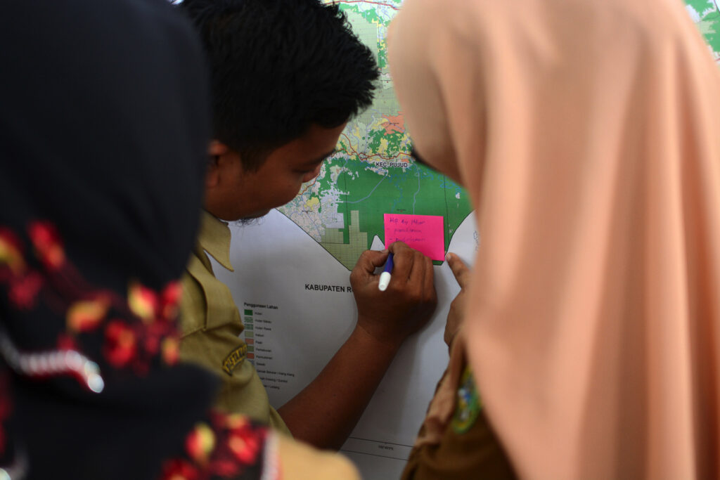
PMaP3 undertook capacity building activities with local government in 11 districts across four provinces (Majene, Polewali Mandar in Sulawesi Barat Province; Luwu, Luwu Utara, Luwu Timur in Sulawesi Selatan Province; Kolaka, Kolaka Timur, Kolaka Utara in Sulawesi Tenggara Province; and Ende, Sikka and Flores Timur in NTT Province. The aim was for spatial information and technology to be more effectively used to develop spatial plans. In particular, this spatial planning incorporated low carbon/renewable energy activities in these plans.
Key services provided
- Collection, collation and analysis of geospatial information for 11 target districts
- Development of a simple GIS-based information management system (including hardware, software, web-based access and customisation)
- Local staff capacity building to effectively use system data – through formal training and on-site mentoring
- Local staff capacity building to develop and improve spatial plans, in accordance with national regulations and to incorporate renewable energy investments
- Stakeholder analysis and development of activities and processes to ensure women and disadvantaged are included and have access to information
- Development of a system to support licensing associated with new investment activities – agricultural, mining, tourism
- Supporting “One-Stop-Shops” for investors
- A review of laws, regulations and legal issues impacting efficient spatial planning and investment.
Infographic video used to deliver key PMaP3 messages to local government and public audiences
An infographic video was used as part of the stakeholder management strategy to provide a comprehensive and uncomplicated overview of PMaP3 to target audiences. It showed how the program was developed to address the problem of land use and space – a result of long-term poor planning and overlaps in spatial information management.
Related to the One Map Policy, a national government priority, PMaP3 encouraged various stakeholders to play an active role in managing district mapping and planning. Since the program involved the technical aspects of district spatial planning in PMaP3 target areas where there were limited human resources, the infographic video was designed to deliver simple and comprehensive key messages on what PMaP3 has been doing to date. Although mainly intended for local government personnel (as the main implementers), the video may also be useful to other audiences.
The video was played during closed meetings with district and provincial government agencies, at trainings and workshops, and during coordination meetings with various stakeholders (eg international non-government organisations, community leaders, etc). To date it has been well received. Approximately 1,900 people have attended these sessions to date.
Click here to view the video.