Project Narrative
In late 2008, Indonesia was selected by the Millennium Challenge Corporation (MCC) Board of Directors as a country eligible for a compact. The Government of Indonesia (GoI; through the National Development Planning/National Development Planning Agency (BAPPENAS)), was responsible for coordinating the development and implementation of the Compact (MCA), which covered three key programs, one of which was the Green Prosperity (GP) Project. The Compact implemented gender activities, environmental assessments and social assessments to support program implementation. Projects such as these responded to constraints to economic growth and were priorities in the GoI’s national development strategy. The GoI also made a commitment to reduce greenhouse gas emissions by 26 percent by 2020, while maintaining a target of seven percent annual economic growth.
The GP Project consisted of four procurement activities: (1) Participatory Land Use Planning Activity (PLUP); (2) Technical Assistance and Oversight Activity; (3) GP Facility Activity, and (4) Green Knowledge Activity. PMaP2 is the second project in a series of eight PLUP sub-activity projects. It covered three main tasks:
- Task 2: Acquisition of geo-spatial data and preparation of geographic information system (GIS) databases on land use/land cover
- Task 3: Compilation and geo-referencing of existing and pending licences and permits for land and natural resource use, and
- Task 4: Enhancing district spatial plans through capacity building in spatial planning, enforcement and management of land use information in spatially-enabled databases.
PMaP2 was undertaking capacity building activities with local government in nine districts across three provinces (Kerinci, Tanjung Jabung Timur – Jambi Province; Lombok Utara, Lombok Tengah, Lombok Timur – NTB Province; Sumba Timur, Sumba Tengah, Sumba Barat, and Sumba Barat Daya – NTT Province). The aim was for spatial information and technology to be more effectively used to develop spatial plans. In particular, this spatial planning incorporated low carbon/renewable energy activities in these plans.
Key services provided:
- Collection, collation and analysis of geospatial information for nine target districts
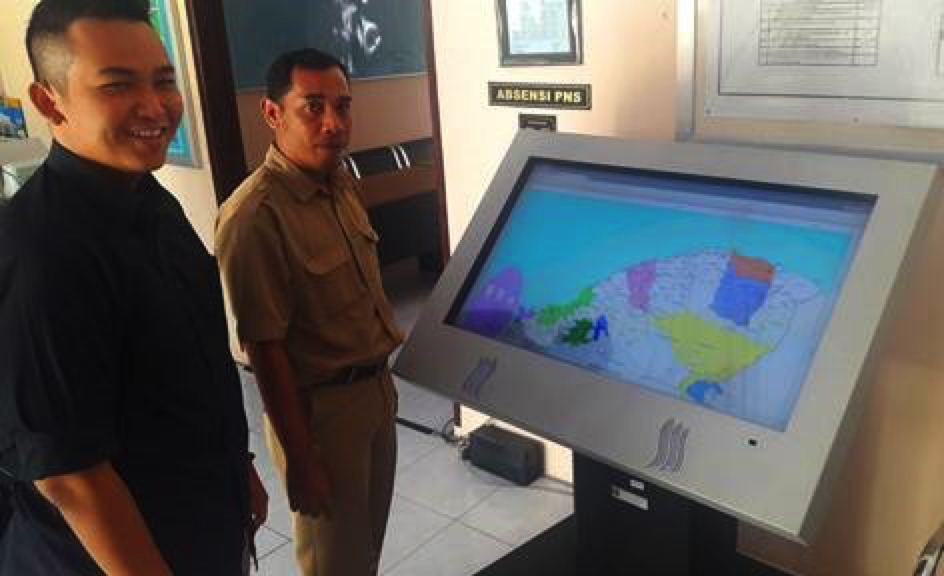
- Development of a simple GIS-based information management system (including hardware, software, web-based access and customisation)
- Local staff capacity building to effectively use system data – through formal training and on-site mentoring
- Local staff capacity building to develop and improve spatial plans, in accordance with national regulations and to incorporate renewable energy investments
- Stakeholder analysis and development of activities and processes to ensure women and disadvantaged are included and have access to information
- Development of a system to support licensing associated with new investment activities – agricultural, mining, tourism
- Supporting “One-Stop-Shops” for investors
- Undertake a review of laws, regulations and legal issues impacting efficient spatial planning and investment.